It’s crazy to think about it, but one of the most critical events in the history and settlement of Michigan didn’t even happen within the state. On July 4 of 1817, construction started on a crucial waterway. The Erie Canal, affectionately known now as The Nation’s First Superhighway, opened up the west, accelerating the region’s settlement and westward expansion. Michigan, especially, benefitted from the Erie Canal, gaining enough pioneers to become a state by 1837.
The Canal Debate
In the early 1800s, Michigan had plenty of good land available. Settlers from the East wanted to relocate to what is now considered the Midwest. However, many of the roads were dirt, full of holes, and often muddy, (we can call them historic potholes) making travel the biggest impediment for decades. The Appalachian Mountains were also a huge barrier, making travel by water the best option. Would-be settlers needed a navigable waterway that would connect the Atlantic Ocean to the Great Lakes.
There were only five places in the Appalachian Mountains where mules or wagons could get through. Even those passes were difficult. Americans knew there had to be a better way to get across them. A mule can carry 250 pounds on its back, but can pull a barge weighing as much as 60,000 pounds along a towpath. A canal to run from the Hudson River to Lake Erie was first proposed in the 1780s. A formal survey to complete the project was finally conducted in 1808.
After much debate, the New York State Legislature authorized the construction of the canal in 1817, with much support from then New York Governor, DeWitt Clinton. The canal would be 363 miles long. At the time, it was second longest in the world, behind China’s Jing–Hang Grand Canal. The land between the starting point and the ending point rises 600 feet from the Hudson to Lake Erie. Fifty locks would be required to complete the project.
Phase One
There were no civil engineers in the United States at this time, and the planners of the project were all novices. James Geddes and Benjamin Wright laid out the route, and the lead engineer was 27-year-old Canvass White. To prepare for the project, White had traveled to England, at his own expense, to study the canals there. Most of the men hired to work were Irish Catholic immigrants and German stonemasons. Though they all were beginners, they became a skilled labor force.
As stated above, construction began on July 4, 1817, in Rome, New York. The canal was cut forty feet wide and four feet deep, with the dirt removed and piled on the downhill side to form a walkway, also known as the towpath. The first fifteen miles from Rome to Utica opened in 1819, which seems like a long time but the inexperienced workers soon learned the ropes. Many of the delays included having to fall trees to clear a path, then digging out the stumps and continuously moving soil.
They also had to construct aqueducts to redirect the water. The workers were constantly making innovations on the fly to get the job done. At Montezuma Marsh, it was reported that 1,000 workers died of Swamp Fever and construction was brought to a halt. Later, the crews worked across the swampland when it froze in the winter.
Canal Expansion
The next phase of the project linked Utica to Salina (now Syracuse). This section was completed in 1820, and traffic started immediately. The portion from Brockport to Albany opened on September 10, 1823. When they had to cross the Irondequoit River, they built an aqueduct that was supported by eleven arches to bring their barges over the river.
The workers needed to innovate again when they reached the Niagara Escarpment. Here, they had to navigate an 80-foot-high wall of limestone by following the channel of the creek that cut a ravine steeply down the embankment.
The canal was finally completed on October 26, 1825, completing a landmark in civil engineering. It vastly reduced the costs of transportation for both people and goods. The completion was commemorated by a statewide grand celebration that included a 90-minute cannonade from Buffalo to New York City. It took eight years, at a cost of 7.143 million dollars, which would be 185 million dollars today.
Moving to Michigan
There were two major types of vessels that traveled the canal. Both freight boats and passenger boats, also known as packets, were pulled by mules or horses. They moved slowly, but methodically and made a relatively comfortable way for passengers to travel. The packets were large wooden vessels that looked like a box and even had straw-padded bunks for overnight travelers. The mules traveled two miles per hour and the trip cost passengers between two and four cents a mile. Once they reached Buffalo, they boarded steamboats for the three-day journey across Lake Erie to Detroit.
Settlers to Michigan could bring everything they would need to start a farm, including farm equipment and livestock. Supplies could also now be moved east to west, as well as west to east, which allowed farmers in the Midwest to more easily move their crops of wheat and flour to markets in New York. Interestingly, the canal also served as one of the last legs of the Underground Railroad, ferrying runaways to Buffalo, where they could then make their way to Canada.
Long-term Impact
The building of the canal is only half the story. The effects of having the canal were quite advantageous. It certainly helped New York City to develop into an international trade center, but its benefits to the state of Michigan cannot be understated. The settlers that came from New England and New York purchased good, inexpensive farmland. It was hard work but well worth it for the opportunity to farm their own land. It also allowed them to transport their products much easier. After the canal opened, 1.5 million acres of land were sold in and around Detroit by 1826. Most of the settlers initially made their home in this area of the Lower Peninsula.
The growth in the population of Michigan is evident when in 1820 there were only 8,000 inhabitants, but by 1830, the numbers increased to an amazing 32,000 people.
The canal continued to be an important trade route with the peak of travel being in 1855. In that year, 33,000 commercial shipments were recorded. The canal started to see its decline with the development of the railroads and by 1902 it was no longer an economical way of transportation.
Today’s Erie Canal
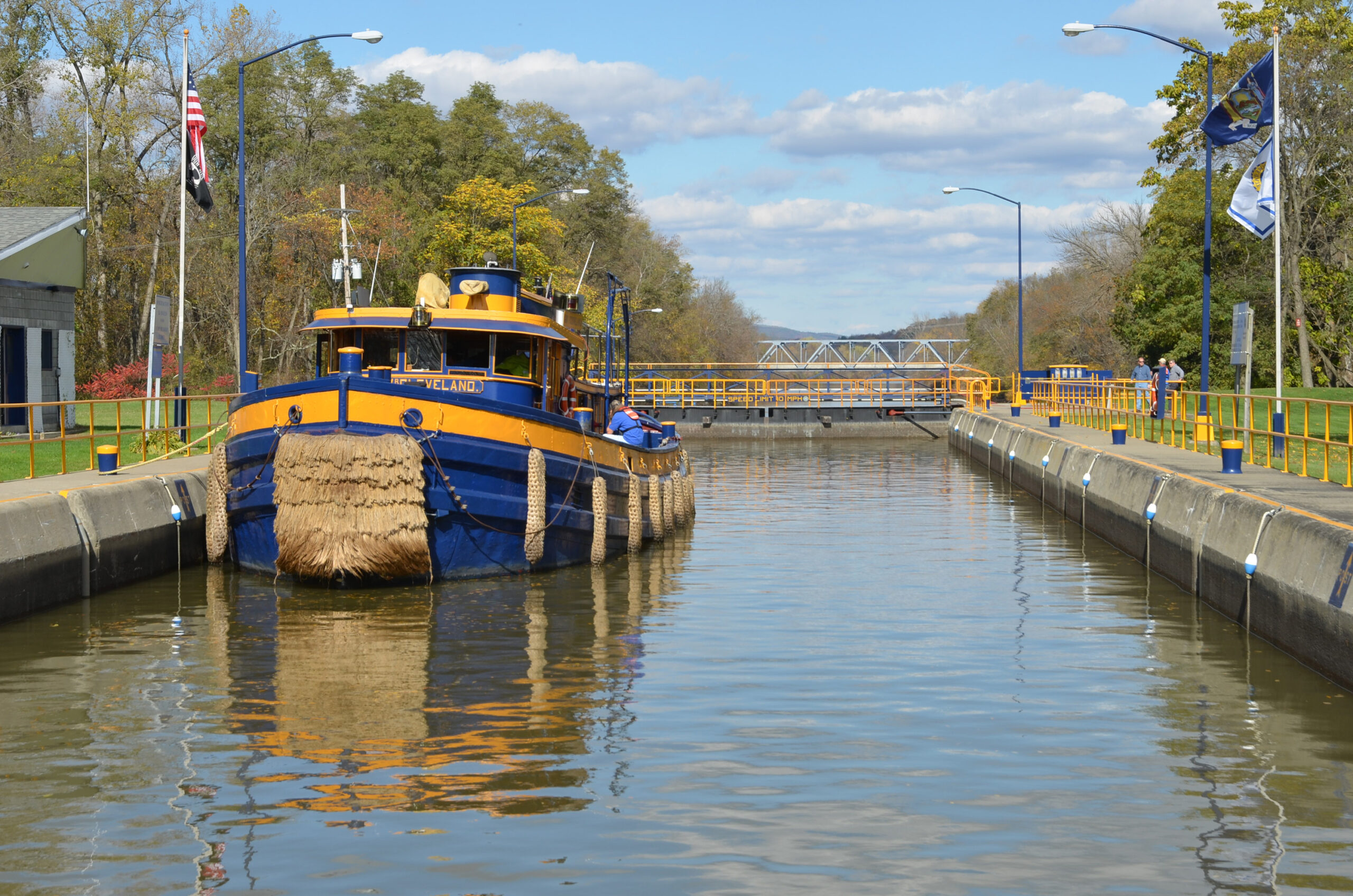
Today, pleasure boats, kayaks, canoes, and commercial vessels share the Erie Canal. It connects the three other canals in the New York State Canal System: the Champlain, Oswego, and Cayuga–Seneca. Some long-distance boaters take the Erie as part of the Great Loop, a continuous waterway that recreational mariners can travel including part of the Atlantic Gulf Intracoastal Waterways, the Great Lakes, the Erie Canals, and other canals and inland rivers.
The canal has become a tourist attraction as well with a number of parks and museums dedicated to its history. The Erie Canalway Trail is a popular cycling path that follows the canal across the state. In the year 2000, Congress designated the Erie Canalway National Heritage Corridor to protect and promote the system. Aside from transportation, numerous businesses, farms, factories and communities alongside its banks still utilize the canal’s waters for other purposes such as irrigation for farmland, hydroelectricity, research, industry, and even drinking.
The building of the Erie Canal is a perfect example of how one state’s decisions can affect others. In this case, the choice of New York to benefit their own state impacted those in the west, most especially Michigan. If it hadn’t been for the Erie Canal, Michigan would have likely lagged behind in becoming a state which would have impacted future change. “Clinton’s Folly” as the canal was once dubbed became a Michigan success. Thanks New York!


Leave A Comment
You must be logged in to post a comment.