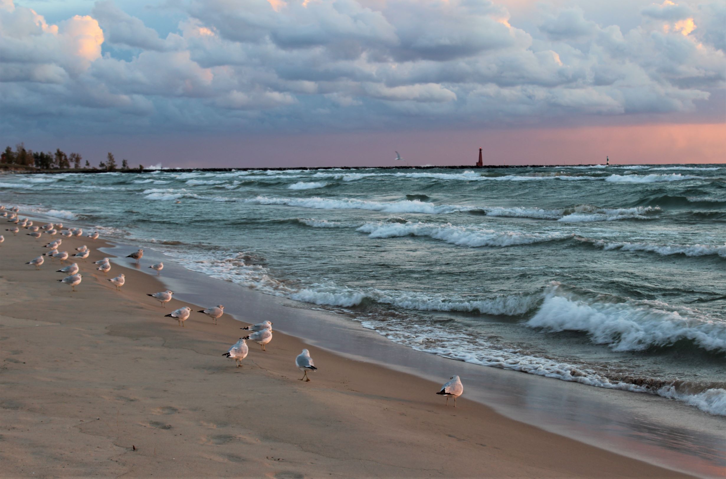
Our Great Lakes are famous for many reasons. They are the largest body of freshwater and are also known as the Sweetwater Seas, but sometimes these waters are not so sweet. The Great Lakes can be downright wicked. The storms produced on the lakes can be detrimental to sailors and their ships, more specifically and often known as the November Gales.
One of these storms that hit Lake Superior in 1975 sank the Edmund Fitzgerald freighter, and inspired a very popular Gordon Lightfoot song. While this may be one of the most famous incidents, it wasn’t the worst storm. Experts say the Thanksgiving storm of 1905 could be argued as the worst, especially from a Lake Superior perspective. Twenty-seven wooden vessels were lost in what has been called the Big Blow. However, one other Great Lakes storm was so destructive, it is called the Freshwater Fury and the White Hurricane. It came through the Midwest from November 7 through November 10, 1913, killing more than 250 people, destroying 19 ships, stranding 19 other ships and resulted in the loss of 68,300 tons of cargo, including coal, iron ore, and grain.
This particular story isn’t just about history. To fully understand, one needs to understand a little bit of weather science. Since the Great Lakes hold so much water, they remain relatively warm far later into the year than many people realize. While this is nice if you want to go for an October or November swim, it’s actually what causes the big storms. When cold, dry air from Canada rolls in, it is warmed by the waters below and picks up a spin, then becomes an extratropical cyclone. These storms can produce hurricane-force wind gusts, create waves of over 50 feet (almost 5 stories) and dump several feet of rain, snow, or a combination of the two. They can also remain over the lakes for days. Now, I’m sure anyone from Michigan can imagine blizzard-like conditions and tons of snow dumping down, but seeing them from a sailor’s perspective is likely much more terrifying.
The 1913 storm began Thursday, November 6 on the western side of Lake Superior, heading south to Michigan. Not much was thought of it at first, especially when the Detroit News predicted “moderate to brisk” winds with occasional rains for the upper lakes and “fair to unsettled” for the lower. The people of the Midwest would soon realize this was not the case. Early 20th Century meteorology was even more unreliable than today’s forecasts. Around midnight Thursday, a steamer, the Cornell, was 50 miles west of Whitefish Point in Lake Superior and ran into a northerly gale. The ship was badly damaged and almost forced ashore.
The next day, the Port Huron Times-Herald described the storm as moderately severe, and predicted increased winds and falling temperatures over the next 24 hours. At 10:00AM, Coast Guard stations at Lake Superior posts indicated a storm warning, and by late afternoon, their flags signaled that a hurricane with winds of over 74mph was coming. Lake Superior winds had already reached 50mph, and a blizzard was moving toward Lake Huron.
By Saturday, November 8, the storm had been upgraded to severe and was centered over eastern Lake Superior. The Port Huron Times-Herald reported that winds had reached gale strength, and Duluth, Minnesota (on Lake Superior) had winds up to 60mph. Many took precautions, but a false lull in the storm, also known as a sucker hole, created a false sense of safety. Traffic on the lakes began to pick up again, down the St. Mary’s River and up Lake Erie, the Detroit and St. Claire rivers, and into Lake Huron. Gale wind signal flags were raised, but ignored by many ship captains. Long ships continued on their charted courses, not realizing the worst was yet to come.
By noon Sunday, November 9, weather conditions on lower Lake Huron were fairly normal for a November gale. At the time, the Weather Bureau issued two daily reports, usually in the morning and after dark. This created a problem, as things were calm in the morning. Down near Erie, Pennsylvania, a low-pressure area was building overnight. It had an intense counter-clockwise rotation, which caused a change in the wind. Gusts up to 80mph blew from noon to almost 5:00PM in cities like Buffalo, New York, and Cleveland, Ohio. Swirling snow added itself to the mix, and ships on Lake Huron south of Alpena were battered with massive waves. Some ships sought shelter along Michigan’s coast, but few survived. Three of the larger ships were found upside down, showing just how destructive the winds and waves were.
From 8:00PM to midnight the storm became what is now called a weather bomb. Hurricane winds of more than 70mph ravaged the four lakes that surround Michigan. The worst damage was done on Lake Huron. Numerous ships caught in the storm sought shelter on the shore. Harbor beach, in the Thumb reported winds of 80mph. Lake masters noted high waves and the wind often blowing opposite the waves below. Most sailors hunkered down, but some tried to be proactive. Three men from the William Nottingham freighter volunteered to leave the ship to search for assistance. As their lifeboat was being lowered, a wave smashed into the ship and the men fell into the almost freezing water. They were never recovered.
Much of the science behind these storms was not understood at the time, given that data was only collected twice a day, and maps were drawn by hand. There were no satellites available so with this system, information was way behind the actual weather conditions by hours, and not always much use.
The damage of the 1913 storms was not just confined to ships. The city of Detroit was hit hard, and images show citizens and police officers trying to stop wagons from tipping over. A lifesaving station in Pointe aux Barques in the Thumb was laid to ruins. Further north, a freighter loaded with ore, the L.C. Waldo, was damaged while trying to reach Lake Superior’s Keweenaw Peninsula. It ended up running aground and breaking in two.
By Monday, November 10, the storm moved toward London, Ontario, and brought lake effect blizzards with it. If you live in West Michigan, you know all about the joys of lake effect snow. Seventeen inches of snow was dumped on Cleveland, Ohio, forcing streetcar operators to wait out the storm in their powerless vehicles for two nights. Some local residents braved the elements and brought the stranded workers food. I survived the Polar Vortex of 2019, but I can’t imagine being stuck inside a frigid streetcar for 2 days.
On the actual lakes, in the late afternoon, an unknown vessel was spotted floating upside down near the mouth of the St. Claire River. Immediately dubbed the mystery ship, it became the focus of the people in that area who wanted to determine its identity. The ship eventually sank to the bottom of the lake, and on November 15, it was finally identified as the Charles S. Price, a fully loaded ore carrier.
By Tuesday the 11th of November, the storm moved into Canada. Without the warm water from the lakes, it quickly lost its strength. Less snow fell as well, as it moved across land. Along the St. Lawrence River, around Montreal, all shipping had stopped the day before, but was able to reopen later that Tuesday.
This storm was unique on many fronts. Historically, storms of that magnitude and conditions would only last for four or five hours. The 1913 storm, however, raged for more than sixteen hours. The average wind speed was 70mph, and it crippled traffic on the lakes and throughout the region. On the shoreline, the blizzards shut down traffic and communication, and caused hundreds of thousands of dollars in damage. Stores were put temporarily out of business, power was out for several days (again, not unlike Snowmageddon, 2019). Telephone and telegraph communications were shut down, and buildings and other structures were blown away. The wind and weather, along with the many unknowns and people being unprepared, all contributed to the losses and damage.
Not surprisingly, the worst of the damage was on the lakes. Each Great Lake except Ontario had at least one major shipwreck. The remains of some of these ships lay unknown for many years, and some have yet to be recovered.
Financial losses included $2,332,000 for vessels lost, $830,900 for ships so damaged they could not be restored (like a ‘totaled’ car), $620,000 for vessels that had been damaged and could return to service, and $1,000,000 in lost cargo. These monetary losses don’t even include the losses on land. An estimated 250 lives were lost as well across all of the lakes, and some on land. Bodies would continue to wash ashore for weeks following the storms, a grim reminder of what had transpired.
The losses were not completely in vain, though. Because of the damage and other results of the storm, the USDA Weather Bureau made increased efforts to get better and more accurate weather forecasting and communication. Shipping companies and shipbuilders met with insurers and mariners to seek safer designs, which led to ships being built with greater stability and more strength.
So as we head into the winter months here in Michigan, and the temptation to lament the weather and its effect on our lives can be strong, we must remember how lucky we are that we have the capability to better predict the storms and their movements ahead of time. We can also take solace in the fact that, while the winds and snows may blow fiercely we are more prepared both on land and especially on the unpredictable Great Lakes when those notorious November gales come rolling in.


Leave A Comment
You must be logged in to post a comment.